California Government Code section 51178 requires the California Department of Forestry and Fire Protection (CAL FIRE) to identify “Very High Fire Hazard Severity Zones” using consistent statewide criteria.
Buildings constructed in areas identified as Very High Fire Hazard Severity Zones are required to be built using fire-resistive features identified in the California Building Code, Chapter 7A - and/or the California Residential Building Code, Section R327 – Materials and Construction Methods for Exterior Wildfire Exposure.
Fire hazard is established using a number of applicable criteria including:
- Vegetation - Vegetation is "fuel" to a wildfire and it changes over time. Fire hazard considers the potential vegetation over a 50 year time horizon
- Topography - Fire burns faster on steep slopes.
- Weather - Fire burns faster and with more intensity when air temperature is high, relative humidity is low, and winds are strong.
- Crown fire potential - Under extreme conditions, fires burn up into trees and tall brush.
- Ember production and movement - Fire brands are blown ahead of the main fire, spreading the fire and getting into buildings and igniting.
- Likelihood of an area burning - over a 30 - 50 year time period.
Government Code section 51181 requires CAL FIRE to periodically review the Very High Fire Hazard Severity Zone areas and make updated recommendations as needed.
Utilizing the latest and best fire modeling methods CAL FIRE has re-evaluated wild-fire hazards and identified Very High Fire Hazard Severity Zones in the state.
Very High Fire Hazard Severity Zones were originally established in 1996 (AB 337 – Bates Bill). The County Board of Supervisors adopted a Fire Hazard Map in 1996. The map was referred to as: Special Fire Protection Areas” or “ SFPA.” This map was for the Local Responsibility Areas (LRA) of unincorporated Orange County.
CAL FIRE issued a new LRA Map in 2011 to replace the 1996 Map and local jurisdictions are required to designate the updated Very High Fire Hazard Severity Zones within 120 days after receiving recommendations from CAL FIRE.
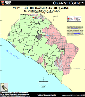
Very High Fire Hazard Severity Zone Map In Unincorporated LRA (Oct 2011)
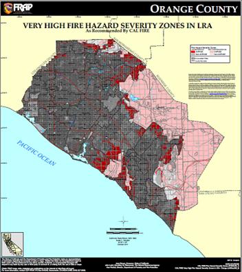
Orange County Very High Fire Hazard Severity Zone Map (Oct 2011)
Launch Cal Fire's Fire Hazard Severity Zone Viewer
Additional wildfire information is available at CAL FIRE and the Orange County Fire Authority.