
Content block block-1713076574-1775688590
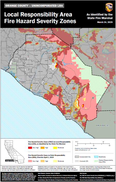
California Government Code section 51178 requires the California Department of Forestry and Fire Protection (CAL FIRE) to identify and map “Fire Hazard Severity Zones” using consistent statewide criteria. On March 24, 2025, CAL FIRE released an updated version of the map from the director of CAL FIRE for an updated Fire Hazard Severity Zone (FHSZ) map in the unincorporated areas of the County of Orange. These maps use the latest climate data, fire history, topography, and wildfire modeling to classify areas as Very High, High, or Moderate Fire Hazard Zones. The Fire Hazard Severity Zones map has been reviewed and adopted by the Board of Supervisors via Ordinance No. 25-015 on August 26, 2025.
Buildings constructed in areas identified as Very High Fire Hazard Severity Zones are required to be build using fire-resistive features identified in the California Building Code, Chapter 7A - and/or the California Residential Building Code, Section R327 - Materials and Construction Methods for Exterior Wildfire Exposure.
Fire hazard is established using a number of applicable criteria including:
- Vegetation - Vegetation is "fuel" to a wildfire and it changes over time. Fire hazard considers the potential vegetation over a 50 year time horizon.
- Topography - Fire burns faster on steep slopes.
- Weather - Fire burns faster and with more intensity when air temperature is high, relative humidity is low, and winds are strong.
- Crown fire potential - Under extreme conditions, fires burn up into trees and tall brush.
- Ember production and movement - Fire brands are blown ahead of the main fire, spreading the fire and getting into buildings and igniting.
- Likelihood of an area burning - over a 30 - 50 year time period.
OC Unincorporated Area Fire Hazard Severity Zones Map
Additional wildfire information is available at CAL FIRE and the Orange County Fire Authority.
Launch Cal Fire's Fire Hazard Severity Zone Viewer.